Google Earth gives us the eagle eye ability to discover new locations virtually. This geobrowser uses satellite and aerial imagery, compiling them into a 3D form of the planet Earth. They are many functions and uses of Google Earth, from finding places or visiting a location virtually, without being physically present. Nevertheless, users around the globe sharing their experiences of using Google Earth.
Most person after they knew about Google Earth, the first thing they would search is their own house, either they are curious or just plain bored. An example is this Japanese Twitter user, @TeacherUfo, who is bored during the Covid-19 pandemic and decided to search for his parent's house. To his surprise, he saw his father, who had passed away seven years ago. His father is seen standing in front of the house, waiting for his mother. He described his father as a quiet person, but also a kind father. In his post, he pleaded that the image of his late father to remain on Google Earth.
コロナでやる事ないからGoogleEarthで実家見に行ったら7年前に死んだ親父が写ってた。その先に人が居たから見に行ったら母ちゃんだった。一服しながら奥さんの帰りを待ってたんだな。無口だけど優しい親父だった。このままこの場所の写真更新しないで欲しいな。 pic.twitter.com/PXxBICAxmz
— タムチンキ (@TeacherUfo) January 4, 2021
@TeacherUfo tweet has gained 699.9K likes and 114K retweets. His experience with Google Earth is also shared by other netizens, who also searched for their old houses. One netizen described Google Earth as a time machine, wondering how many memories are kept on the Internet.
Apart from searching your own house, you too can use Google Earth to track the flight’s path of an aeroplane. Kompas.com used Google Earth to track down the disaster Indonesian flight path, Sriwijaya Air SJ182 that crashed in the sea off the Thousand Island on 9 January 2021. Their tracking method uses the KML (keyhole markup language) flight history data downloaded from Flightradar24, a flight tracker website. The KML file of SJ182 is then imported into Google Earth, and it shows the flight’s path in 3D. Using this method make it easier to visualize SJ182 flight’s history on that fateful day.
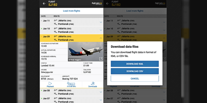
SJ182 KML from Flightradar24. Image source via Kompas.com
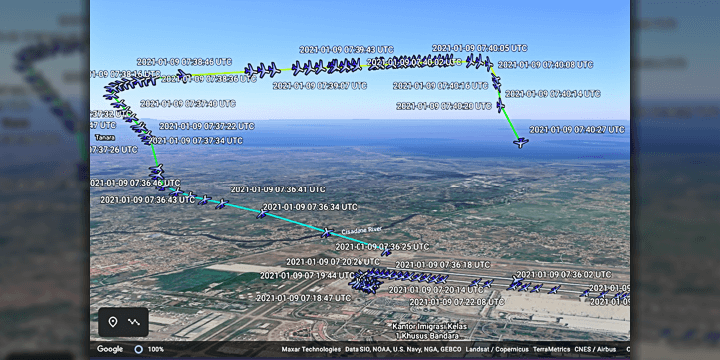
SJ182 flight path displayed in Google Earth. Image source via Kompas.com
SJ182 was routed from Jakarta to Pontianak, flew above 11,000 feet and suddenly lost altitude. The last data Flightradar24 gained from the aeroplane is about 11 nautical miles from Soekarno–Hatta International Airport. However, for new users, the information gained from Flightradar24 and Google Earth regarding the fateful flight SJ182 is not official, so users are advised to use it on their discretion.
Not everything about Google Earth is gloomy. Since the geobrowser has captured most place on Earth, it is bound that something around the globe will catch our attention. TikTok profile, hidden.on.google.earth has compiled many fascinating finds from Google Earth, ranging from funny mishaps or spooky encounters.
@hidden.on.google.earth ???????????? @the.larics #fyp #hiddenongoogleearth #googleearth #googlemaps #viral #streetview #funny #lol
♬ original sound - Google Earth
@hidden.on.google.earth this has to be the wierdest ones yet???? #googleearth #googlemaps #hiddenongoogleearth #streetview #fyp #trending #viral #scary #creepy #horror
♬ original sound - sk1ttle
Even Malaysia has its own Google Earth moments, although it is not appropriate.

You can find this wheelie guy by searching 3°05'19.0 Image source via No Context Malaysia
What is your take on Google Earth? Especially in this pandemic time, where many places have movement restriction. Take this opportunity to do your virtual visiting, and maybe you too would find something interesting in your virtual adventure. STAY SAFE!!!